


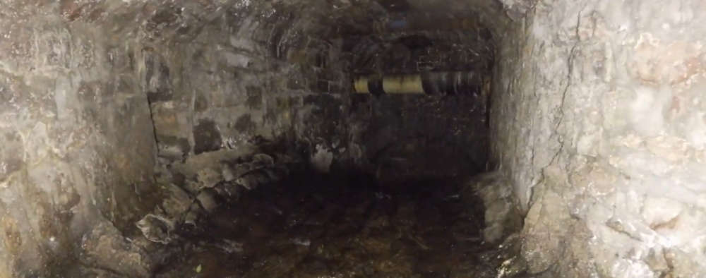
A flood defence scheme in Caernarfon has revealed the hidden history of a river beneath the town centre.
Work is continuing on a £675,000 project which will eventually provide protection for nearly 120 properties - including 80 homes.
It's allowed engineers to see the underground path of the River Cadnant, which flows underneath the town but has been left hidden for generations.
Emyr Gareth, Cyngor Gwynedd's chief engineer, said: "Although the Cadnant is a small river, it has influenced the development of the town of Caernarfon for centuries."
He added: "We have installed a new screen that prevents rubbish and debris from entering the river Cadnant channel. Should the river channel become blocked under the town's streets, it could cause flooding and major problems for the local community."
Footage has been released from a drone, which was sent underground by engineers to follow the river course for 900 metres. Up until now, the only clue to what has been hidden beneath Caernarfon has come from street names.
The River Cadnant disppears underground near the roundabout between Ffordd Llanberis, Ffordd Bethel and Tanrallt, where the new rubbish screen has been installd.
The river flows through a series of hidden culverts, which were enlarged during Victorian times.
Key to the Cadnant's path is the Penllyn area, where the multi-storey car park stands today. A small lake was located here for around 800 years and the last section of the culvert was completed in 1997. This lends its name to Penllyn and Stryd y Llyn (Pool Street).
The culvert consists of a number of unique pieces due to its age and the nature of its construction - and the lake emptied through bridge arches, turning a water mill further down its path. Such features give their names to Ffordd y Felin (Mill Lane) and Bont Bridd (Bridge Street).
The river drops by around fourt metres under Bont Bridd near Canfolan Penllyn, before flowing out into the Menai via a culvert at Victoria Dock, where the Cadnant was channelled in 1868 by the Caernarfon Harbour Trust.
When the tide allows, bubbles can be seen rising to surface near the Records Office building.

Cllr June Jones, cabinet member for engineering, said: "Over the years, Caernarfon's infrastructure has been shaped by the river."
"Our priority today is of course to protect the town's homes and businesses from flooding and I'm delighted that we've been able to work with the Welsh Government and invest in this project for the benefit of the local community."
"The video taken as part of the engineering work is extremely interesting and I'm sure people will be interested to learn about the river."
"Who would have thought that a contemporary project and the use of modern technology would have helped us to connect with the history of the town of Caernarfon?"
The flood defence scheme has been joint funded by the Welsh Government and Cyngor Gwynedd.
Deputy First Minister, Huw Irranca-Davies, added: "Our investment in this scheme, of nearly £590,000, will deliver long-term benefits to over 119 properties in the area – and is yet another example of our unwavering commitment to address the challenges we face from climate change."
"In recent years, we have invested more than £377 million to protect communities across Wales from increasingly unpredictable and extreme weather, with this year's record funding rising to £85 million."


 Holyhead man charged with sex attack
 Salon owner fined for cosmestics fraud
 RAF instructor's paragliding death 'accidental'
 New parking system at Newborough Forest
 Funding available for community schemes